Hydrogeological Survey for Groundwater Detection
Introduction
Groundwater plays a crucial role in sustaining agriculture, infrastructure development, and industrial growth across India. Many rural communities depend entirely on borewells and open wells for irrigation and domestic water supply. At the same time, modern infrastructure projects, residential developments, and solar power plants also require reliable groundwater sources to function efficiently.
https://bhoojalsurvey.in/hydrogeological-survey.php
However, in recent years the number of failed borewells has increased significantly. In many areas, people invest large amounts of money in drilling without any scientific investigation, only to discover that the borewell produces little or no water. This problem occurs because underground water is not evenly distributed and depends heavily on geological formations, fractures, and aquifer structures.
A Hydrogeological Survey provides a scientific and reliable approach to solving this issue. Instead of relying on guesswork, this method studies subsurface conditions to identify potential groundwater zones before drilling begins. Through geological analysis and modern resistivity techniques, a Hydrogeological Survey helps farmers, builders, industries, and infrastructure planners locate groundwater with higher accuracy and reduced financial risk.
Understanding Hydrogeological Survey
A Hydrogeological Survey is a scientific investigation of underground water conditions based on geological and hydrological principles. It studies the behavior, distribution, and movement of groundwater within soil and rock formations. The objective of a Hydrogeological Survey is to identify aquifers, determine water table depth, and recommend suitable locations for borewell or open well construction.
The science behind hydrogeology combines geological mapping, groundwater flow analysis, and geophysical techniques. During a Hydrogeological Survey, experts examine surface geology, rock structures, fractures, and weathered zones that influence groundwater storage.
Modern technology has significantly improved the efficiency of a Hydrogeological Survey. Electrical resistivity survey techniques are widely used to detect subsurface variations. These techniques measure how strongly underground formations resist electrical current. Water-bearing zones usually show lower resistivity compared to compact dry rocks.
By interpreting resistivity patterns along with geological observations, hydrogeologists can identify aquifer layers and determine the most promising drilling points. This combination of science and technology makes a Hydrogeological Survey one of the most reliable methods for groundwater detection.
Importance Before Borewell Drilling
Before drilling a borewell, conducting a Hydrogeological Survey can prevent costly mistakes and increase the chances of success. Many borewells fail because drilling locations are selected randomly without studying subsurface water conditions.
A Hydrogeological Survey helps identify potential aquifers and fracture zones that can store and transmit groundwater. When drilling is done at these scientifically identified points, the probability of obtaining sufficient water increases significantly.
Financial savings are another major advantage. Borewell drilling involves expenses related to machinery, labor, casing pipes, and pumping systems. If drilling fails, all these costs are lost. By conducting a Hydrogeological Survey beforehand, landowners can avoid unnecessary drilling attempts.
Accurate borewell location selection is also important for long-term sustainability. A Hydrogeological Survey evaluates groundwater recharge capacity and aquifer thickness, ensuring that the well continues to provide water over extended periods.
For farmers and infrastructure developers, this scientific approach ensures that water supply planning is reliable and efficient.
Methods Used in Hydrogeological Survey
A professional Hydrogeological Survey uses several technical methods to understand subsurface water conditions. One of the most widely used techniques is the Electrical Resistivity Method. This method involves sending electrical current into the ground through electrodes and measuring the resistance offered by underground layers.
Different geological materials show different resistivity values. Dry rocks typically have higher resistivity, while water-bearing formations show lower values. By analyzing these variations, experts can determine aquifer depth and thickness during a Hydrogeological Survey.
Soil resistivity testing is another important technique used in groundwater investigations. This method helps identify the structure of underground layers, including weathered zones and fractured formations where groundwater accumulation is likely.
Groundwater profiling is also carried out during a Hydrogeological Survey. This process includes studying water table levels, geological formations, and recharge conditions to estimate groundwater potential at the site.
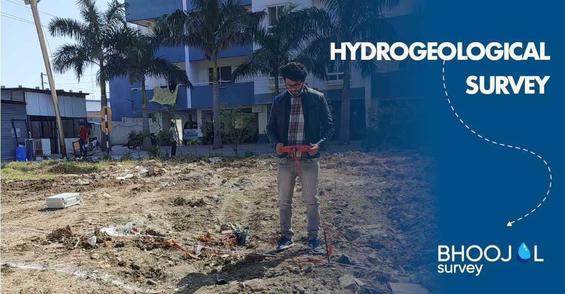
Modern groundwater detection instruments improve survey accuracy and efficiency. In advanced field investigations, experts may be conducting hydrogeological survey using SSRMPATS Instrument, GER DETECT, and PQWT at site for open well / borewell location. These advanced instruments help collect real-time subsurface data and assist hydrogeologists in interpreting groundwater potential more precisely.
Through the integration of geological knowledge and geophysical technology, a Hydrogeological Survey provides dependable results for groundwater exploration.
Applications Across Different Sectors
The Hydrogeological Survey has become an essential service for many sectors that depend on groundwater. In agriculture, farmers rely on borewells for irrigation, especially in regions where rainfall is unpredictable. A Hydrogeological Survey helps them locate water sources more effectively, reducing the risk of dry wells.
In residential and commercial construction projects, developers require a consistent water supply for long-term operations. Conducting a Hydrogeological Survey before construction ensures that groundwater resources are available and sustainable.
Solar power projects also require water for cleaning photovoltaic panels and maintaining infrastructure. A Hydrogeological Survey helps project planners evaluate groundwater availability and plan water management systems accordingly.
Industries with high water consumption often depend on groundwater extraction. In such cases, a Hydrogeological Survey helps determine the safe yield capacity of aquifers and prevents overexploitation.
Land developers and farmhouse owners also use Hydrogeological Survey services to ensure that their properties have reliable groundwater access.
Advantages of Professional Hydrogeological Survey
A professionally conducted Hydrogeological Survey offers several advantages compared to random drilling. The most important benefit is scientific accuracy. Hydrogeologists use field data, geological interpretation, and resistivity measurements to locate groundwater zones with greater reliability.
Technical documentation is another advantage of a Hydrogeological Survey. Experts provide detailed reports that include geological observations, resistivity graphs, aquifer depth estimates, and recommended drilling points.
Cost efficiency improves when drilling decisions are based on survey results. A Hydrogeological Survey minimizes the chances of failed borewells and reduces unnecessary drilling expenses.
Another key benefit is long-term groundwater sustainability. By analyzing recharge patterns and aquifer characteristics, a Hydrogeological Survey ensures that groundwater extraction remains balanced and environmentally responsible.
Choosing Reliable Survey Experts
Selecting experienced professionals is important for obtaining accurate Hydrogeological Survey results. Hydrogeological conditions vary widely across different regions of India, and local geological knowledge is essential for proper interpretation.
Professional survey teams use advanced instruments and calibrated equipment to collect accurate data. Their experience in analyzing geological formations allows them to provide precise recommendations for borewell drilling.
Field data interpretation plays a crucial role in the success of a Hydrogeological Survey. Skilled experts combine geophysical measurements with geological observations to identify productive groundwater zones.
Site-specific recommendations provided by professionals help farmers, builders, and industrial planners make informed decisions regarding water supply development.
Conclusion
Groundwater exploration requires scientific understanding rather than guesswork. A Hydrogeological Survey provides a reliable and technically sound method for locating underground water resources with greater precision.
By studying geological formations, analyzing resistivity data, and identifying aquifer zones, a Hydrogeological Survey significantly improves borewell success rates. It helps farmers secure irrigation water, supports infrastructure projects, and ensures sustainable groundwater management.
Before investing in borewell drilling, conducting a professional Hydrogeological Survey is one of the most effective steps toward reliable water resource planning.
For professional and accurate Hydrogeological Survey services, visit:
https://bhoojalsurvey.in/hydrogeological-survey.php
It is ok to contact this poster with commercial interests.
Call seller